
1920 Map of Clarks Hill
USGS Topo · Published 1920About this map
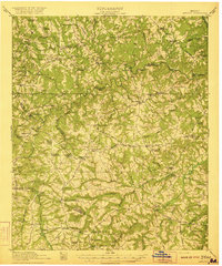
Gilchrist Ferry and Dents Ferry cross the Savannah River in this detailed survey, illustrating the critical river-based transport network connecting South Carolina and Georgia before modern bridge systems. The landscape is defined by the sharp transition from the uplands of McCormick Co and Edgefield Co down to the river bottoms, where Price Island and Little Germain Island split the flow. The rural economy of the 1920s is evidenced by the density of small community centers like Clarks Hill and Meriwether, alongside numerous country institutions such as Hosannah Church, Red Oak Grove School, and Dorn School. Industrial presence begins to emerge at the Power Dam on Stevens Creek, while the Charleston and Western Carolina railroad provides the primary land-based logistical link through the region, serving sidings like Griffith Siding and Johnston Spur.
Find a feature on this map
76 named features on this map. Tap any name to fly to it.
Don’t see what you’re looking for? This feature index may not catch every label — zoom into the map to look around manually.
Map Details
Editions of this 1920 Clarks Hill Map
This is the sole edition of this map. No revisions or reprints were ever made.
Other maps of this area

1892 · Mc Cormick
USGS Topo · 1:125,000

1912 · Mc Cormick
USGS Topo · 1:125,000

1921 · Augusta
USGS Topo · 1:62,500

1921 · Clarks Hill
USGS Topo · 1:62,500
1921 · Appling
USGS Topo · 1:62,500

1922 · Harlem
USGS Topo · 1:62,500

1922 · Hephzibah
USGS Topo · 1:62,500

1923 · Warrenville
USGS Topo · 1:48,000

1928 · Warrenville
USGS Topo · 1:62,500

1941 · Clarks Hill
USGS Topo · 1:62,500