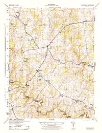
1944 Map of Clarksville
USGS Topo · Published 1944About this map
Clarksville serves as the central hub for this 1944 War Department survey, which highlights the rural landscape of southern Howard County during the mid-century. The map meticulously records the local social geography, from the Dayton School and Highland School to prominent houses of worship like Mt Zion Church, Linden Church, and Hopkins Chapel. The terrain is defined by the winding course of the Middle Patuxent River and the Patuxent River, which forms the boundary with Montgomery County to the south. Transportation and infrastructure of the era are visible through several labeled spans, including Snell Bridge, Iron Bridge, and Hammond Bridge. Further utility is noted at the Pumping Station and Transformer Station near the river, reflecting the local infrastructure supporting the growing communities of Fulton, Simpsonville, and Scaggsville.
Find a feature on this map
30 named features on this map. Tap any name to fly to it.
Don’t see what you’re looking for? This feature index may not catch every label — zoom into the map to look around manually.
Map Details
Editions of this 1944 Clarksville Map
This is the sole edition of this map. No revisions or reprints were ever made.
Other maps of this area

1892 · Laurel
USGS Topo · 1:62,500

1892 · Ellicott
USGS Topo · 1:62,500

1893 · Frederick
USGS Topo · 1:125,000

1894 · Ellicott
USGS Topo · 1:62,500

1894 · Laurel
USGS Topo · 1:62,500

1894 · Frederick
USGS Topo · 1:125,000

1897 · Laurel
USGS Topo · 1:62,500

1906 · Ellicott
USGS Topo · 1:62,500

1907 · Laurel
USGS Topo · 1:62,500

1908 · Patapsco
USGS Topo · 1:125,000