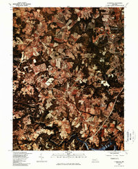
1981 Map of Clarksville
USGS Topo · Published 1986About this map
Columbia and its surrounding communities are captured in this 1981 orthophotoquad, which utilizes color infrared imagery to reveal the complex landscape of Howard County. The transition from established agricultural fields to the burgeoning suburban development of Clarksville and Dayton is visible through the distinct patterns of wooded corridors and cleared tracts. Hydrological patterns define the region, with the Middle Patuxent River cutting through the center and the Patuxent River feeding into the Rocky Gorge Reservoir in the south and the Triadelphia Reservoir in the west. This aerial perspective, produced in cooperation with the Soil Conservation Service, offers an unfiltered view of the road networks and land use changes near Highland during a period of significant growth in central Maryland.
Find a feature on this map
8 named features on this map. Tap any name to fly to it.
Don’t see what you’re looking for? This feature index may not catch every label — zoom into the map to look around manually.
Map Details
Editions of this 1981 Clarksville Map
This is the sole edition of this map. No revisions or reprints were ever made.
Other maps of this area

1892 · Laurel
USGS Topo · 1:62,500

1892 · Ellicott
USGS Topo · 1:62,500

1893 · Frederick
USGS Topo · 1:125,000

1894 · Ellicott
USGS Topo · 1:62,500

1894 · Laurel
USGS Topo · 1:62,500

1894 · Frederick
USGS Topo · 1:125,000

1897 · Laurel
USGS Topo · 1:62,500

1906 · Ellicott
USGS Topo · 1:62,500

1907 · Laurel
USGS Topo · 1:62,500

1908 · Patapsco
USGS Topo · 1:125,000