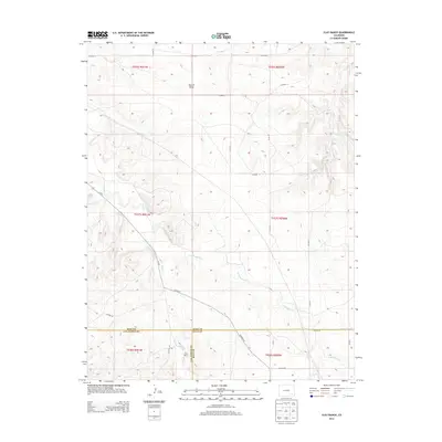
2013 Map of Clay Ranch
USGS Topo · Published 2013About this map
Clay Ranch serves as the primary landmark in this corner of Colorado, where the boundaries of Las Animas, Bent, and Baca counties converge. The landscape is defined by a series of intermittent watercourses, including the north-trending Ruxton Draw and the winding paths of Rule Cr and Cottonwood Cr. This 2013 survey reveals a high-plains geography etched by a network of rural routes such as Co-101 and Co Hwy B. The topographic data illustrates the gradual elevation changes across this section of the state, centered on the ranching infrastructure and the natural drainage patterns of Caddoa Cr in the northeast. The map provides a clear view of the public land survey system divisions and the specific intersections of county lines that shaped the jurisdictional history of the region.
Find a feature on this map
29 named features on this map. Tap any name to fly to it.
Don’t see what you’re looking for? This feature index may not catch every label — zoom into the map to look around manually.
Map Details
Editions of this 2013 Clay Ranch Map
This is the sole edition of this map. No revisions or reprints were ever made.
Other maps of this area

1891 · Higbee
USGS Topo · 1:125,000

1892 · Two Butte
USGS Topo · 1:125,000

1893 · Higbee
USGS Topo · 1:125,000

1893 · Two Butte
USGS Topo · 1:125,000

1955 · La Junta
USGS Topo · 1:250,000

1958 · La Junta
USGS Topo · 1:250,000

1966 · Toonerville SE
USGS Topo · 1:24,000
1966 · Toonerville
USGS Topo · 1:24,000

1967 · Hand Springs
USGS Topo · 1:24,000

1968 · La Junta
USGS Topo · 1:250,000