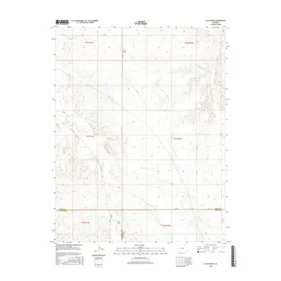
2016 Map of Clay Ranch
USGS Topo · Published 2016About this map
Clay Ranch serves as a central landmark in this high-plains landscape where Las Animas, Bent, and Baca counties converge. The terrain is defined by a series of intermittent drainage systems, including the southward reach of Ruxton Draw and the winding course of Cottonwood Cr. These natural watercourses dictated the placement of early ranching infrastructure and the rural road network that persists today. Transportation across this sparsely populated section of southeastern Colorado is anchored by State Hwy 101, which cuts through the western portion of the map. This 2016 survey illustrates the long-standing land divisions of the Public Land Survey System, showing the townships and ranges that organized this cattle-country frontier. Smaller waterways like Rule Cr and Caddoa Cr provide further geographic context for researchers tracing property lines or historical land use in this corner of the state.
Find a feature on this map
26 named features on this map. Tap any name to fly to it.
Don’t see what you’re looking for? This feature index may not catch every label — zoom into the map to look around manually.
Map Details
Editions of this 2016 Clay Ranch Map
This is the sole edition of this map. No revisions or reprints were ever made.
Other maps of this area

1891 · Higbee
USGS Topo · 1:125,000

1892 · Two Butte
USGS Topo · 1:125,000

1893 · Higbee
USGS Topo · 1:125,000

1893 · Two Butte
USGS Topo · 1:125,000

1955 · La Junta
USGS Topo · 1:250,000

1958 · La Junta
USGS Topo · 1:250,000

1966 · Toonerville SE
USGS Topo · 1:24,000
1966 · Toonerville
USGS Topo · 1:24,000

1967 · Hand Springs
USGS Topo · 1:24,000

1968 · La Junta
USGS Topo · 1:250,000