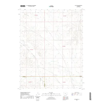
2019 Map of Clay Ranch
USGS Topo · Published 2019About this map
Clay Ranch serves as a lonely human outpost in this arid corner of Southeast Colorado, situated near the intersection of three counties. The landscape is defined by the drainage patterns of Cottonwood Cr and Rule Cr, which carve through the high plains toward the Arkansas River basin. A complex network of county roads, such as Co RD A and Co RD 18, connects the scattered ranching operations across the section lines of the Public Land Survey System. The meeting of Bent, Las Animas, and Baca counties in the southern portion of the map highlights the area's role as a remote borderland. The path of State Hwy 101 cuts diagonally across the western sections, providing the primary link between these isolated rangelands and the wider region.
Find a feature on this map
28 named features on this map. Tap any name to fly to it.
Don’t see what you’re looking for? This feature index may not catch every label — zoom into the map to look around manually.
Map Details
Editions of this 2019 Clay Ranch Map
This is the sole edition of this map. No revisions or reprints were ever made.
Other maps of this area

1891 · Higbee
USGS Topo · 1:125,000

1892 · Two Butte
USGS Topo · 1:125,000

1893 · Higbee
USGS Topo · 1:125,000

1893 · Two Butte
USGS Topo · 1:125,000

1955 · La Junta
USGS Topo · 1:250,000

1958 · La Junta
USGS Topo · 1:250,000

1966 · Toonerville SE
USGS Topo · 1:24,000
1966 · Toonerville
USGS Topo · 1:24,000

1967 · Hand Springs
USGS Topo · 1:24,000

1968 · La Junta
USGS Topo · 1:250,000