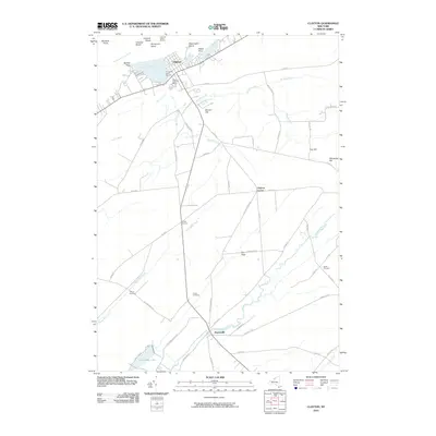
2010 Map of Clayton
USGS Topo · Published 2010About this map
The Saint Lawrence River shapes the northern edge of this Thousand Islands gateway, where the village of Clayton serves as a focal point for maritime activity. In the early 21st century, the shoreline at French Creek Bay and Goose Bay remains a hub for local industry, evidenced by the Thousand Island Marina and French Creek Marina. Moving inland, the landscape transitions to the agricultural and residential outskirts of Smith Corners and Clayton Center.
Find a feature on this map
63 named features on this map. Tap any name to fly to it.
Don’t see what you’re looking for? This feature index may not catch every label — zoom into the map to look around manually.
Map Details
Editions of this 2010 Clayton Map
This is the sole edition of this map. No revisions or reprints were ever made.
Other maps of this area

1900 · Clayton
USGS Topo · 1:62,500

1903 · Grindstone
USGS Topo · 1:62,500

1903 · Clayton
USGS Topo · 1:62,500

1903 · Alexandria Bay
USGS Topo · 1:62,500

1903 · Theresa
USGS Topo · 1:62,500

1942 · Chaumont
USGS Topo · 1:31,680

1942 · Sawmill Bay
USGS Topo · 1:31,680

1942 · Clayton
USGS Topo · 1:24,000
1943 · Dexter
USGS Topo · 1:31,680

1943 · Thousand Island Park
USGS Topo · 1:31,680