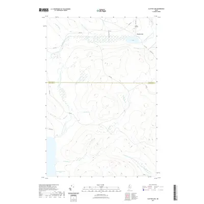
2021 Map of Clayton Lake
USGS Topo · Published 2021About this map
Clayton Lake serves as a central hub for this remote Maine landscape, where the Clayton Lake Strip and Air Strip Rd suggest a reliance on aerial access for the local timber and recreational economy. The terrain is defined by a dense network of waterways, including the winding Chemquasabamticook Stream and Priestly Brook, which flow through the timberlands of T10 R14 WELS. The boundary between Aroostook and Piscataquis counties bisects the map, marking a transition across this managed forest. Logging infrastructure is prominent, with the primary Realty Rd and secondary routes like Churchill Rd and Ross Mt Rd providing overland transit. Primitive camping at the Kelly Brk Campsite and the southern reach of Chemquasabamticook Lake highlight the area's role as a destination for outdoor sportsmen and foresters in the North Maine Woods.
Find a feature on this map
25 named features on this map. Tap any name to fly to it.
Don’t see what you’re looking for? This feature index may not catch every label — zoom into the map to look around manually.
Map Details
Editions of this 2021 Clayton Lake Map
This is the sole edition of this map. No revisions or reprints were ever made.
Other maps of this area

1932 · Umsaskis Lake
USGS Topo · 1:48,000

1935 · Umsaskis Lake
USGS Topo · 1:62,500

1954 · Churchill Lake
USGS Topo · 1:62,500

1954 · Allagash Lake
USGS Topo · 1:62,500

1954 · Presque Isle
USGS Topo · 1:250,000

1955 · Clayton Lake
USGS Topo · 1:62,500

1958 · Presque Isle
USGS Topo · 1:250,000

1960 · Presque Isle
USGS Topo · 1:250,000

1961 · Allagash Lake
USGS Topo · 1:62,500
1962 · Churchill Lake
USGS Topo · 1:62,500
Featured Places
- T10 R14 WELS, ME
- Clayton Lake Township, ME
- T10 R15 WELS, ME
- T11 R15 WELS, ME
- Clayton Lake, Clayton Lake Township