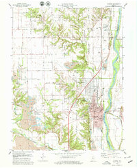
1978 Map of Clinton
USGS Topo · Published 1979About this map
The Wabash River serves as the eastern boundary for this Indiana landscape, where the industry of Clinton and surrounding townships is clearly etched into the terrain. Extensive Strip Mine operations dominate the western and southern sections, particularly around Centenary and Universal, revealing the intensive coal extraction that shaped the local economy. The city of Clinton is a dense hub of civic and religious life, featuring landmarks like the Municipal Bldg, the Sacred Heart Sch, and Riverside Cem.
Find a feature on this map
67 named features on this map. Tap any name to fly to it.
Don’t see what you’re looking for? This feature index may not catch every label — zoom into the map to look around manually.
Map Details
Editions of this 1978 Clinton Map
2 editions found
Other maps of this area

1947 · Ridge Farm
USGS Topo · 1:62,500

1947 · Paris
USGS Topo · 1:62,500

1949 · Paris
USGS Topo · 1:62,500

1950 · Rosedale
USGS Topo · 1:24,000

1950 · New Goshen
USGS Topo · 1:24,000

1950 · Sandford
USGS Topo · 1:24,000

1951 · Clinton
USGS Topo · 1:24,000

1951 · Mecca
USGS Topo · 1:24,000

1951 · Saint Bernice
USGS Topo · 1:24,000

1953 · Indianapolis
USGS Topo · 1:250,000