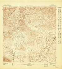
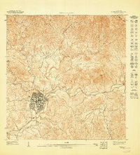
1947 Map of Coamo SE
USGS Topo · Published 1947About this map
Hacienda Lago and Sabana Llana sit at the center of this 1943 topographic study, revealing the agricultural and military landscape of southern Puerto Rico during the mid-century era. The map details the transition from the steep, interior peaks of Cerro Cariblanco and Cerro Pío Juan down toward the coastal plains. This topography is defined by a dense network of watercourses, including the Río Jueyes and Río Lapa, which carve through the terrain near the boundaries of Municipio de Coamo and Municipio de Salinas.
Find a feature on this map
13 named features on this map. Tap any name to fly to it.
Don’t see what you’re looking for? This feature index may not catch every label — zoom into the map to look around manually.
Map Details
Editions of this 1947 Coamo SE Map
This is the sole edition of this map. No revisions or reprints were ever made.
Other maps of this area

1945 · Central Aguirre
USGS Topo · 1:30,000

1945 · Salinas
USGS Topo · 1:30,000

1946 · Coamo
USGS Topo · 1:30,000

1946 · Cayey
USGS Topo · 1:30,000

1947 · Cayey NO
USGS Topo · 1:10,000

1947 · Cayey SO
USGS Topo · 1:10,000
1947 · Salinas NE
USGS Topo · 1:10,000
1947 · Coamo SO
USGS Topo · 1:10,000
1947 · Coamo NE
USGS Topo · 1:10,000
1947 · Coamo NO
USGS Topo · 1:10,000