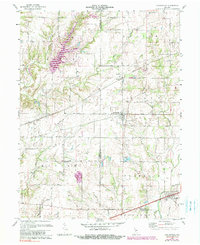
1970 Map of Coatesville
USGS Topo · Published 1983About this map
Coatesville and the surrounding agricultural landscapes of Hendricks and Putnam Counties are documented here as they appeared in the early 1970s. The settlement of Coatesville sits centrally, bisected by the Conrail line, which also passes through the nearby village of Reno and a designated Pumping Sta. The rural character of the region is defined by a dense network of watercourses, including the serpentine path of Mononchala Creek and the headwaters of Mill Creek. Local landmarks such as Canaan Ch and Bethel Ch, along with numerous small family cemeteries, provide essential reference points for those researching the genealogical and ecclesiastical history of Floyd and Marion townships. To the south, the village of Stilesville marks the lower boundary of the survey near East Fork Mill Creek, illustrating the region's enduring reliance on natural drainage and established rail corridors for its economic structure.
Find a feature on this map
26 named features on this map. Tap any name to fly to it.
Don’t see what you’re looking for? This feature index may not catch every label — zoom into the map to look around manually.
Map Details
Editions of this 1970 Coatesville Map
Other maps of this area

1953 · Clayton
USGS Topo · 1:24,000

1953 · Danville
USGS Topo · 1:24,000

1953 · Indianapolis
USGS Topo · 1:250,000

1955 · Hall
USGS Topo · 1:24,000

1956 · Indianapolis
USGS Topo · 1:250,000

1956 · Cloverdale
USGS Topo · 1:24,000

1956 · Eminence
USGS Topo · 1:24,000

1957 · Indianapolis
USGS Topo · 1:250,000

1958 · Roachdale
USGS Topo · 1:24,000

1958 · Coatesville
USGS Topo · 1:24,000