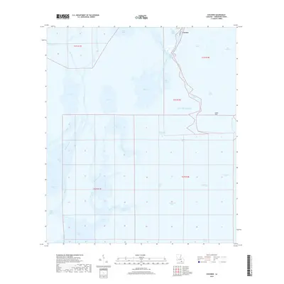
2018 Map of Cocodrie
USGS Topo · Published 2018About this map
Cocodrie serves as a lone outpost at the edge of the Gulf of Mexico, marking the terminus of the road network where the coastal marsh gives way to the open sea. This 2018 survey reveals an intricate hydraulic landscape where the Houma Navigation Canal and Bayou Petit Caillou provide essential maritime arteries through a labyrinth of saltwater bays and winding passes. The map documents a fragile coastal environment characterized by sprawling water bodies like Bay Sainte Elaine and the uniquely named Bay Touch-me-not. Between the deeper waters of Deep Saline and the tidal channels of Oyster Bayou, the terrain consists of fragmented marshland and narrow natural levees. For those studying the evolution of the Terrebonne Parish shoreline, this map records the delicate balance of sediment and sea, tracing named features such as Cooke Point and the Tambour Cutoff that define the modern coastal boundary.
Find a feature on this map
42 named features on this map. Tap any name to fly to it.
Don’t see what you’re looking for? This feature index may not catch every label — zoom into the map to look around manually.
Map Details
Editions of this 2018 Cocodrie Map
This is the sole edition of this map. No revisions or reprints were ever made.
Other maps of this area

1894 · Bayou De Large
USGS Topo · 1:62,500

1894 · Dulac
USGS Topo · 1:62,500

1935 · Cocodrie
USGS Topo · 1:31,680

1935 · Bourbeux
USGS Topo · 1:31,680

1935 · Lake Quitman
USGS Topo · 1:31,680

1940 · Bayou Du Large
USGS Topo · 1:62,500

1941 · Bayou Du Large
USGS Topo · 1:62,500

1941 · Dulac
USGS Topo · 1:62,500
1944 · Dulac
USGS Topo · 1:62,500

1944 · Bayou Du Large
USGS Topo · 1:62,500