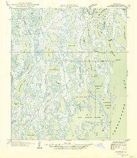
1945 Map of Cocodrie
USGS Topo · Published 1945About this map
Bay Cocodrie and the intricate coastal wetlands of Terrebonne Parish are captured here during a period of extensive aerial surveying by the U.S. Army Air Corps. This 1945 sheet, compiled from mid-1930s field examinations, reveals a landscape defined by an complex network of interconnected waterways and marshlands. Significant bodies of water like Bay Sainte Elaine and Tambour Bay dominate the southern portion of the quadrangle, connected to the larger Terrebonne Bay by natural passes such as Ste Elaine Pass. The map meticulously details the labyrinth of bayous, including Petit Bayou, Pumpkin Bayou, and the curiously named Bay Touch-Me-Not. This record is vital for understanding the historical geomorphology of the Louisiana coast before modern coastal erosion significantly altered these shorelines, showing the precise locations of landmarks like Cooke Pt and the Tambour Cutoff.
Find a feature on this map
36 named features on this map. Tap any name to fly to it.
Don’t see what you’re looking for? This feature index may not catch every label — zoom into the map to look around manually.
Map Details
Editions of this 1945 Cocodrie Map
This is the sole edition of this map. No revisions or reprints were ever made.
Other maps of this area

1894 · Bayou De Large
USGS Topo · 1:62,500

1894 · Dulac
USGS Topo · 1:62,500

1935 · Cocodrie
USGS Topo · 1:31,680

1935 · Bourbeux
USGS Topo · 1:31,680

1935 · Lake Quitman
USGS Topo · 1:31,680

1940 · Bayou Du Large
USGS Topo · 1:62,500

1941 · Bayou Du Large
USGS Topo · 1:62,500

1941 · Dulac
USGS Topo · 1:62,500
1944 · Dulac
USGS Topo · 1:62,500

1944 · Bayou Du Large
USGS Topo · 1:62,500