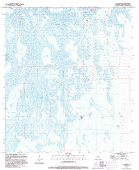
1994 Map of Cocodrie
USGS Topo · Published 1994About this map
Cocodrie stands at the northern edge of a landscape defined by an intricate network of marshes and waterways transitioning into the open expanse of Terrebonne Bay. This 1994 map reflects the intense industrial footprint of the energy sector upon the Louisiana coast, where the Sainte Elaine Oil Field and the Deep Saline Gas Field dominate the topography. These fields are marked by numerous offshore platforms, a radio tower, and specialized navigation aids like the Light near Pass la Poule.
Find a feature on this map
46 named features on this map. Tap any name to fly to it.
Don’t see what you’re looking for? This feature index may not catch every label — zoom into the map to look around manually.
Map Details
Editions of this 1994 Cocodrie Map
This is the sole edition of this map. No revisions or reprints were ever made.
Other maps of this area

1894 · Bayou De Large
USGS Topo · 1:62,500

1894 · Dulac
USGS Topo · 1:62,500

1935 · Cocodrie
USGS Topo · 1:31,680

1935 · Bourbeux
USGS Topo · 1:31,680

1935 · Lake Quitman
USGS Topo · 1:31,680

1940 · Bayou Du Large
USGS Topo · 1:62,500

1941 · Bayou Du Large
USGS Topo · 1:62,500

1941 · Dulac
USGS Topo · 1:62,500
1944 · Dulac
USGS Topo · 1:62,500

1944 · Bayou Du Large
USGS Topo · 1:62,500