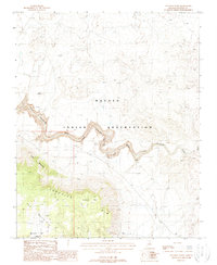
1988 Map of Coconino Point
USGS Topo · Published 1988About this map
The Navajo Indian Reservation spans the northern reaches of this territory, where the arid landscape is defined by the deep incision of the Little Colorado River. At the heart of the area, the Little Colorado River Gorge cuts through the desert floor, featuring a Gagng Station and a specific Gage Zero 3979 measurement point that reflects the hydrological importance of this river in the late 20th century. High elevations are dominated by the Coconino Rim and Gray Mountain, rising sharply above the basin.
Find a feature on this map
18 named features on this map. Tap any name to fly to it.
Don’t see what you’re looking for? This feature index may not catch every label — zoom into the map to look around manually.
Map Details
Editions of this 1988 Coconino Point Map
This is the sole edition of this map. No revisions or reprints were ever made.
Other maps of this area

1886 · San Francisco Mtns
USGS Topo · 1:250,000

1886 · Echo Cliffs
USGS Topo · 1:250,000

1891 · San Francisco Mtns
USGS Topo · 1:250,000

1891 · Echo Cliffs
USGS Topo · 1:250,000

1894 · San Francisco Mtns
USGS Topo · 1:250,000

1899 · San Francisco Mtns
USGS Topo · 1:250,000

1947 · Flagstaff
USGS Topo · 1:250,000

1954 · Flagstaff
USGS Topo · 1:250,000

1955 · Coconino Pt SE
USGS Topo · 1:24,000

1955 · Coconino Pt NE
USGS Topo · 1:24,000