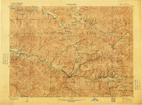
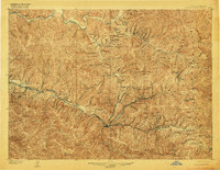
1906 Map of Coeur D'Alene District
USGS Topo · Published 1918About this map
Silver and lead mining operations dominate this mountainous landscape during the height of the Coeur D'Alene district's production. The heavy industrial concentration is evident along the South Fork Coeur d'Alene River, where the Northern Pacific and Oregon-Washington Railroad & Navigation Co. lines serve a dense network of major operations like the Bunker Hill and Sullivan Mine and the Hecla Mine. Deep underground activity is marked by significant engineering feats such as the Kellogg Tunnel and the Morning Mine Tunnel. Settlements such as Wallace, Kellogg, and Mullan appear as established hubs amidst a terrain of peaks including Sunset Peak and Tiger Peak. To the north, the terrain around Murray and the North Fork Coeur d'Alene River reflects the earlier placer mining era of the region.
Find a feature on this map
102 named features on this map. Tap any name to fly to it.
Don’t see what you’re looking for? This feature index may not catch every label — zoom into the map to look around manually.
Map Details
Editions of this 1906 Coeur D'Alene District Map
3 editions found
Other maps of this area

1901 · Coeur D'Alene District
USGS Topo · 1:62,500

1903 · Coeur D'Alene District
USGS Topo · 1:62,500

1906 · Coeur D'Alene District
USGS Topo · 1:62,500

1909 · Cataldo
USGS Topo · 1:125,000

1911 · Cataldo
USGS Topo · 1:125,000

1914 · Avery
USGS Topo · 1:125,000

1917 · Avery
USGS Topo · 1:125,000

1932 · Trout Creek
USGS Topo · 1:125,000

1935 · Trout Creek
USGS Topo · 1:125,000

1936 · Trout Creek
USGS Topo · 1:125,000