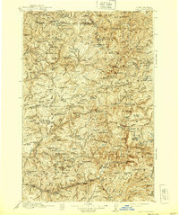
1913 Map of Lolo
USGS Topo · Published 1939About this map
Moose City and the Blacklead Mining District occupy a landscape defined by the drainage of the North Fork Clearwater River and the high mountain passes of the Bitterroot Range. This 1913 survey, updated in 1939, details a frontier geography where resource extraction and federal management intersect. The historic Lolo Trail threads through the northern territory, passing through Indian Post Office and connecting remote outposts like Williams Ranch.
Find a feature on this map
188 named features on this map. Tap any name to fly to it.
Don’t see what you’re looking for? This feature index may not catch every label — zoom into the map to look around manually.
Map Details
Editions of this 1913 Lolo Map
2 editions found
Other maps of this area

1901 · Hamilton
USGS Topo · 1:125,000

1911 · Lolo
USGS Topo · 1:250,000

1912 · Missoula
USGS Topo · 1:125,000

1913 · Lolo
USGS Topo · 1:250,000

1914 · Avery
USGS Topo · 1:125,000

1917 · Avery
USGS Topo · 1:125,000

1918 · St Regis
USGS Topo · 1:125,000

1919 · St. Regis
USGS Topo · 1:125,000

1923 · Washington Creek
USGS Topo · 1:125,000
1924 · Weippe
USGS Topo · 1:125,000