Loading...
Loading map...1924 Map of Weippe
USGS Topo · Published 1924About this map
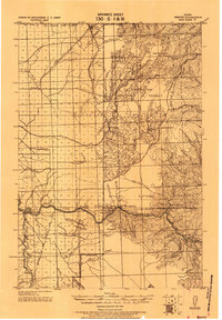
Pierce City and the surrounding timberlands of the Clearwater National Forest define this 1920s tactical survey of north-central Idaho. The map reveals a landscape transitions from the agricultural flats of the Weippe prairie into the deep river canyons of the Middle Fork Clearwater River and the South Fork Clearwater River. Small settlements and individual homesteads are scattered throughout, including locations for G.W. Ford, Bob Kyle, and the Tahoe post office.
Find a feature on this map
65 named features on this map. Tap any name to fly to it.
Don’t see what you’re looking for? This feature index may not catch every label — zoom into the map to look around manually.
Map Details
Date Portrayed1924
Date Published1924
PublisherU.S. Geological Survey
Map TypeTopographic
Scale1:125,000
Physical Dimensions14.7 x 21.1 inches
Editions of this 1924 Weippe Map
This is the sole edition of this map. No revisions or reprints were ever made.
Historical Maps of Kooskia Through Time
1 maps found
Featured Locations
Source Details
SourceU.S. Geological Survey
CopyrightPublic Domain