
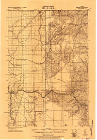
1931 Map of Buffalo Hump
USGS Topo · Published 1957About this map
Nez Perce National Forest dominates this topographic study, where the steep canyons of the South Fork Clearwater River and Crooked River define a landscape of early 20th-century mining and ranching. The survey highlights a rugged interior economy of isolated claims and camps, from the Mother Lode Mine and Iron Crown Mine to the remote Ransoms Cabin. Settlement patterns follow the water and the ridges, with nodes of activity at Old Golden, Orogrande, and the settlement of Humptown near the prominent Buffalo Hump summit.
Find a feature on this map
107 named features on this map. Tap any name to fly to it.
Don’t see what you’re looking for? This feature index may not catch every label — zoom into the map to look around manually.
Map Details
Editions of this 1931 Buffalo Hump Map
This is the sole edition of this map. No revisions or reprints were ever made.
Other maps of this area

1911 · Lolo
USGS Topo · 1:250,000

1913 · Lolo
USGS Topo · 1:250,000

1924 · Kamiah
USGS Topo · 1:125,000
1924 · Weippe
USGS Topo · 1:125,000

1934 · Buffalo Hump
USGS Topo · 1:125,000

1938 · Riggins
USGS Topo · 1:96,000

1945 · Riggins
USGS Topo · 1:125,000

1955 · Pullman
USGS Topo · 1:250,000

1955 · Grangeville
USGS Topo · 1:250,000
1956 · Burgdorf
USGS Topo · 1:62,500