
1924 Map of Kamiah
USGS Topo · Published 1924About this map
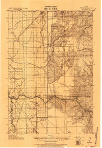
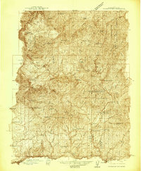
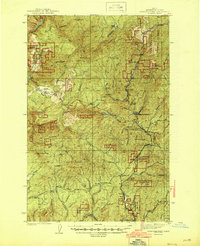
Kamiah and the surrounding Clearwater River valley are depicted here in detail following a tactical survey by the Corps of Engineers. This regional overview highlights the critical transport networks of the early twentieth century, including the Northern Pacific railroad and the Lewiston Nez Perce R. R. which served the plateau agricultural lands. A Toll Bridge at Kamiah marks a vital crossing point over the Clearwater River, while deep incisions like Lawyers Canyon and Big Canyon Creek define the physical geography between upland settlements like Ferdinand and Cottonwood.
Find a feature on this map
51 named features on this map. Tap any name to fly to it.
Don’t see what you’re looking for? This feature index may not catch every label — zoom into the map to look around manually.
Map Details
Editions of this 1924 Kamiah Map
This is the sole edition of this map. No revisions or reprints were ever made.
Other maps of this area

1923 · Washington Creek
USGS Topo · 1:125,000
1924 · Weippe
USGS Topo · 1:125,000

1931 · Buffalo Hump
USGS Topo · 1:125,000

1934 · Buffalo Hump
USGS Topo · 1:125,000
1938 · Headquarters
USGS Topo · 1:48,000
1944 · Headquarters
USGS Topo · 1:62,500

1955 · Pullman
USGS Topo · 1:250,000

1955 · Grangeville
USGS Topo · 1:250,000

1956 · Elk City
USGS Topo · 1:250,000

1956 · Hamilton
USGS Topo · 1:250,000