
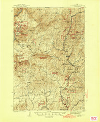
1944 Map of Headquarters
USGS Topo · Published 1944About this map
Headquarters serves as the industrial and logistical hub for this portion of the Clearwater National Forest in northern Idaho. The 1944 landscape reflects a timber-driven economy, evidenced by the presence of the Clearwater Timber Protective Association Headquarters and several specialized rail points like Murphy Siding and Alan Siding. A network of lookout stations, including Riverview Lookout and Shanghai Lookout, tops the high ridges to monitor the valuable timber stands. Beyond logging, the map documents mineral exploration at the Democrat Mines and Crawford Mine. Notable early 20th-century dwellings such as Casey Cabin and Newsham Cabin are recorded alongside family-named landmarks like John Lewis Lookout, showing the footprint of early settlers and foresters in the steep drainage basins of the Clearwater River and Lightning Creek.
Find a feature on this map
55 named features on this map. Tap any name to fly to it.
Don’t see what you’re looking for? This feature index may not catch every label — zoom into the map to look around manually.
Map Details
Editions of this 1944 Headquarters Map
2 editions found
Other maps of this area

1923 · Washington Creek
USGS Topo · 1:125,000

1924 · Kamiah
USGS Topo · 1:125,000

1924 · Weippe
USGS Topo · 1:125,000

1936 · Boehls Butte
USGS Topo · 1:48,000

1938 · Headquarters
USGS Topo · 1:48,000

1943 · Boehls Butte
USGS Topo · 1:62,500

1955 · Pullman
USGS Topo · 1:250,000

1956 · Hamilton
USGS Topo · 1:250,000

1958 · Pullman
USGS Topo · 1:250,000

1959 · Hamilton
USGS Topo · 1:250,000