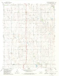
1980 Map of Coldwater NE
USGS Topo · Published 1980About this map
The Old Indian Treaty Boundary cuts a prominent horizontal line across this high plains landscape, a geographic remnant of the nineteenth-century frontier. Positioned on the border of Kiowa and Comanche counties, the terrain is defined by the headwaters of several key watercourses, including the North Branch Medicine Lodge River and the Medicine Lodge River itself, alongside Mule Creek and Cavalry Creek. While the settlement at Harold appears as a small node of activity, the primary industrial character of the region in the late twentieth century is defined by its extensive Oil and Gas Field. A network of subterranean infrastructure is evident through multiple labels for Pipeline corridors, punctuated by scattered Gas Well and Drill Hole locations. This survey captures a moment where ranching and energy extraction exist within the historical framework established by early territorial divisions like Highland and Reeder.
Find a feature on this map
14 named features on this map. Tap any name to fly to it.
Don’t see what you’re looking for? This feature index may not catch every label — zoom into the map to look around manually.
Map Details
Editions of this 1980 Coldwater NE Map
This is the sole edition of this map. No revisions or reprints were ever made.
Other maps of this area

1889 · Kinsley
USGS Topo · 1:125,000

1892 · Kinsley
USGS Topo · 1:125,000

1892 · Coldwater
USGS Topo · 1:125,000

1894 · Kinsley
USGS Topo · 1:125,000

1955 · Pratt
USGS Topo · 1:250,000

1959 · Pratt
USGS Topo · 1:250,000

1968 · Brenham
USGS Topo · 1:24,000
1969 · Greensburg
USGS Topo · 1:24,000
1969 · Mullinville
USGS Topo · 1:24,000

1979 · Coldwater
USGS Topo · 1:24,000