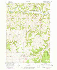
1957 Map of Colesburg
USGS Topo · Published 1980About this map
Colesburg and its surrounding townships in Clayton, Delaware, and Dubuque counties define this interior landscape as it appeared following a 1957 field check with later 1978 updates. The terrain is deeply incised by the Turkey River and Little Turkey River, which flow through a network of hollows like Rock Hollow and Devils Hollow. This map is particularly valuable for genealogists, as it documents numerous small rural burial grounds and community focal points, including the Hansel Cem, Bolsinger Cem, and Zion Ch.
Find a feature on this map
36 named features on this map. Tap any name to fly to it.
Don’t see what you’re looking for? This feature index may not catch every label — zoom into the map to look around manually.
Map Details
Editions of this 1957 Colesburg Map
2 editions found
Other maps of this area

1902 · Elkader
USGS Topo · 1:125,000

1957 · Turkey River
USGS Topo · 1:24,000

1957 · Colesburg
USGS Topo · 1:24,000

1959 · Dubuque
USGS Topo · 1:250,000

1961 · Dubuque
USGS Topo · 1:250,000

1962 · Dubuque
USGS Topo · 1:250,000
1962 · New Vienna
USGS Topo · 1:24,000
1962 · Garnavillo
USGS Topo · 1:24,000

1962 · Petersburg
USGS Topo · 1:24,000
1962 · Guttenberg
USGS Topo · 1:24,000