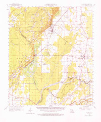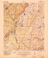
1935 Map of Collinston
USGS Topo · Published 1935About this map
Carbon production and chemical manufacturing define the industrial landscape of northern Louisiana in this mid-1930s survey. Extensive facilities for the Southern Carbon Co, United Carbon Co, and Peerless Carbon Co are concentrated near Swartz and Spyker, connected by an intricate network of gas pipelines and the tracks of the Missouri Pacific RR. The map illustrates a region transitioning between upland pine forests and the fertile alluvial plains of the Boeuf River and Bayou Lafourche.
Find a feature on this map
80 named features on this map. Tap any name to fly to it.
Don’t see what you’re looking for? This feature index may not catch every label — zoom into the map to look around manually.
Map Details
Editions of this 1935 Collinston Map
This is the sole edition of this map. No revisions or reprints were ever made.