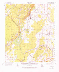
1957 Map of Collinston
USGS Topo · Published 1976About this map
Bayou Bartholomew and the Missouri Pacific railroad corridor dictate the settlement patterns of this Morehouse Parish landscape. The town of Collinston serves as a central hub, where the rail lines intersect near Salem Ch No 2 and Trouser Hill. To the west, the Gas Field underlines the industrial importance of the region, while the Fairbanks Lookout Tower stands as a sentinel over the bottomlands. The map reveals a dense network of country churches and family cemeteries, such as Little Bethany Ch and the Trouser Hill Cem, which provide essential points of interest for genealogical research. Further east, the landscape transitions into the drainage basins of Bayou Bonne Idee and the Boeuf River, where small communities like Oak Ridge and Brodenax are established amidst a complex system of sloughs and brakes.
Find a feature on this map
92 named features on this map. Tap any name to fly to it.
Don’t see what you’re looking for? This feature index may not catch every label — zoom into the map to look around manually.
Map Details
Editions of this 1957 Collinston Map
3 editions found

Other maps of this area

1935 · Collinston
USGS Topo · 1:62,500

1935 · Naff
USGS Topo · 1:62,500

1935 · Alto
USGS Topo · 1:62,500

1935 · Baskinton
USGS Topo · 1:62,500

1935 · Hurricane
USGS Topo · 1:62,500

1935 · Bonita
USGS Topo · 1:62,500

1935 · Drew
USGS Topo · 1:62,500

1935 · Haile
USGS Topo · 1:62,500

1940 · Monroe
USGS Topo · 1:62,500

1955 · Jackson
USGS Topo · 1:250,000