
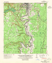
1940 Map of Monroe
USGS Topo · Published 1942About this map
The Ouachita River defines the central spine of this landscape, its serpentine path bordered by complex swamp and wetland features like Cheniere Brake and Gourd Brake. During this era of the early 1940s, the river served as a vital industrial and transport artery, evidenced by the numerous river gages and landings marking its banks. North of the city centers, the La Training Institute for Boys and Mitchell Sch serve as prominent landmarks in the growing corridor between West Monroe and Brownville.
Find a feature on this map
49 named features on this map. Tap any name to fly to it.
Don’t see what you’re looking for? This feature index may not catch every label — zoom into the map to look around manually.
Map Details
Editions of this 1940 Monroe Map
2 editions found
Other maps of this area

1935 · Collinston
USGS Topo · 1:62,500

1935 · Alto
USGS Topo · 1:62,500

1935 · Drew
USGS Topo · 1:62,500

1939 · Fort Necessity
USGS Topo · 1:62,500

1940 · Columbia
USGS Topo · 1:62,500

1952 · Calhoun
USGS Topo · 1:62,500

1953 · Chatham
USGS Topo · 1:62,500

1954 · Sikes
USGS Topo · 1:62,500

1955 · Jackson
USGS Topo · 1:250,000

1955 · Shreveport
USGS Topo · 1:250,000