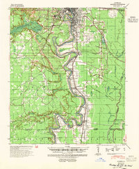
1940 Map of Monroe
USGS Topo · Published 1954About this map
The Ouachita River serves as the central artery for this 1940s landscape, winding through a complex network of bayous and landings. Industrial and maritime activity is evident near Monroe and West Monroe, where the U S Lock & Dam No 4 and a local Pumping Plant manage the river's flow. Beyond the city centers, the terrain transitions into significant wetlands, including the expansive Cypress Brake and Cheniere Brake to the west. A specialized local economy is revealed through the numerous boat landings such as Roselawn Ldg, Logtown Ldg, and Waco Ldg that dot the riverbanks. The map also documents important social and educational institutions of the era, from rural centers like Bawcomville and Logtown to the La Training Institute for Boys and several country churches like Watsons Ch and Cuba Ch.
Find a feature on this map
66 named features on this map. Tap any name to fly to it.
Don’t see what you’re looking for? This feature index may not catch every label — zoom into the map to look around manually.
Map Details
Editions of this 1940 Monroe Map
2 editions found
Other maps of this area

1935 · Collinston
USGS Topo · 1:62,500

1935 · Alto
USGS Topo · 1:62,500

1935 · Drew
USGS Topo · 1:62,500

1939 · Fort Necessity
USGS Topo · 1:62,500

1940 · Monroe
USGS Topo · 1:62,500

1940 · Columbia
USGS Topo · 1:62,500

1952 · Calhoun
USGS Topo · 1:62,500

1953 · Chatham
USGS Topo · 1:62,500

1954 · Sikes
USGS Topo · 1:62,500

1955 · Jackson
USGS Topo · 1:250,000