2024 Map of Collinsville
USGS Topo · Published 2024About this map
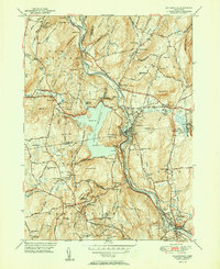
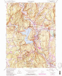
The Farmington River carves a deep valley through this Hartford County landscape, where industrial heritage meets protected wilderness. The town of Collinsville sits at the heart of the map, situated at a historic power site on the river below the Collinsville Reservoir. To the west, the massive Nepaug Reservoir dominates the terrain, its creation having fundamentally altered the local geography and road networks. The map identifies numerous small settlements including Pine Meadow, Puddle Town, and Canton Valley, each connected by thoroughfares like the Albany Tpke and Litchfield Tpke.
Find a feature on this map
83 named features on this map. Tap any name to fly to it.
Don’t see what you’re looking for? This feature index may not catch every label — zoom into the map to look around manually.
Map Details
Editions of this 2024 Collinsville Map
This is the sole edition of this map. No revisions or reprints were ever made.
Historical Maps of Avon Through Time
3 maps found