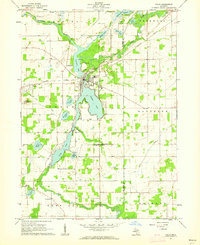
1961 Map of Colon
USGS Topo · Published 1962About this map
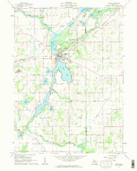
The St Joseph River meanders through the northern reaches of this St. Joseph County landscape, feeding a complex chain of glacial lakes including Sturgeon Lake, Palmer Lake, and Long Lake. At the center of this aquatic network, the village of Colon serves as a focal point, situated on a narrow strip of land between the waters. The mid-century rural character is defined by the New York Central railroad corridor and a series of schools such as Culver Sch and Needham Sch. Genealogists will find notable detail in the distribution of local cemeteries, including Lakeside Cem near the village and the South Colon Cem further south. The map also documents local religious life with the Mennonite Ch and St Pauls Ch serving the surrounding agricultural community, while scattered extraction sites like the Marl Pit and numerous Gravel Pits indicate the local geological industry.
Find a feature on this map
44 named features on this map. Tap any name to fly to it.
Don’t see what you’re looking for? This feature index may not catch every label — zoom into the map to look around manually.
Map Details
Editions of this 1961 Colon Map
2 editions found
Other maps of this area

1918 · Union City
USGS Topo · 1:62,500

1918 · Leonidas
USGS Topo · 1:62,500

1944 · Leonidas
USGS Topo · 1:62,500

1947 · Union City
USGS Topo · 1:62,500

1947 · Leonidas
USGS Topo · 1:62,500

1950 · Leonidas
USGS Topo · 1:62,500

1950 · Union City
USGS Topo · 1:62,500

1953 · Fort Wayne
USGS Topo · 1:250,000

1956 · Fort Wayne
USGS Topo · 1:250,000

1958 · Grand Rapids
USGS Topo · 1:250,000