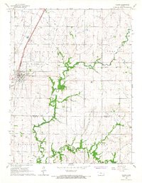
1966 Map of Colony
USGS Topo · Published 1967About this map
Colony serves as the central hub of this mid-1960s Kansas landscape, situated where the Atchison Topeka and Santa Fe railroad line intersects with local commerce. The map reveals a transition in transportation and land use, marked by several instances of an Old RR Grade and an Old Railroad Grade that cut across the prairie, indicating former rail paths no longer in active use.
Find a feature on this map
16 named features on this map. Tap any name to fly to it.
Don’t see what you’re looking for? This feature index may not catch every label — zoom into the map to look around manually.
Map Details
Editions of this 1966 Colony Map
This is the sole edition of this map. No revisions or reprints were ever made.
Other maps of this area

1885 · Garnett
USGS Topo · 1:125,000

1886 · Iola
USGS Topo · 1:125,000

1893 · Iola
USGS Topo · 1:125,000

1894 · Garnett
USGS Topo · 1:125,000

1904 · Iola
USGS Topo · 1:125,000

1947 · Lawrence
USGS Topo · 1:250,000

1947 · Joplin
USGS Topo · 1:250,000

1949 · Joplin
USGS Topo · 1:250,000

1950 · Lawrence
USGS Topo · 1:250,000

1954 · Joplin
USGS Topo · 1:250,000