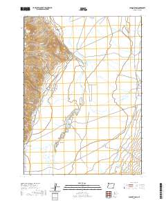
2020 Map of Colony Ranch
USGS Topo · Published 2020About this map
Pueblo Mountains dominate the western edge of this High Desert landscape in Harney County, where the transition from high peaks to the floor of Pueblo Valley is marked by a network of seasonal drainages. The Colony Ranch serves as a central landmark in this ranching country, situated near the confluence of Colony Cr and the complex wetlands of Pueblo Slough. The mapping details a system of secondary roads, including the Fields-Denio Rd, which follow the natural contours of the basin floor. To the south, the terrain levels out across Mapes Flat and the Sand Hills, reflecting the arid, expansive character of southeastern Oregon. Numerous creeks, such as Van Horn Cr and Cherry Cr, suggest a land shaped by intermittent water flow from the higher elevations to the west toward the valley bottom.
Find a feature on this map
26 named features on this map. Tap any name to fly to it.
Don’t see what you’re looking for? This feature index may not catch every label — zoom into the map to look around manually.
Map Details
Editions of this 2020 Colony Ranch Map
This is the sole edition of this map. No revisions or reprints were ever made.
Other maps of this area

1886 · Disaster
USGS Topo · 1:250,000

1893 · Disaster
USGS Topo · 1:250,000

1954 · Vya
USGS Topo · 1:250,000

1955 · Adel
USGS Topo · 1:250,000

1957 · Adel
USGS Topo · 1:250,000

1958 · Vya
USGS Topo · 1:250,000

1958 · Adel
USGS Topo · 1:250,000

1961 · Trident Peak
USGS Topo · 1:62,500

1962 · Vya
USGS Topo · 1:250,000

1962 · Adel
USGS Topo · 1:250,000