1954 Map of Colorado City
USGS Topo · Published 1975About this map
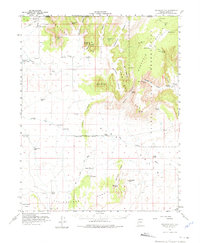
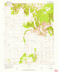
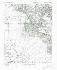
Colorado City and the surrounding high desert of the Arizona Strip are defined here by a scattered network of essential water sources and remote cattle ranching infrastructure. Situated near the Utah border, the landscape is dominated by the massive Vermilion Cliffs and the Kaibab Indian Reservation, where the community of Moccasin (PO) sits near several vital springs. The 1950s survey shows a reliance on deep desert wells and tanks to support the region, including Brinkerhoff Well, Gudger Well, and the Lakes of Short Creek. Family-named landmarks such as Esplins Corral and isolated outposts like Cane Beds provide important genealogical touchstones, while a network of primitive roads and a Jeep Trail through the Moccasin Mountains illustrate the difficulty of travel across the Pipe Valley and Yellowstone Mesa before modern improvements.
Find a feature on this map
61 named features on this map. Tap any name to fly to it.
Don’t see what you’re looking for? This feature index may not catch every label — zoom into the map to look around manually.
Map Details
Editions of this 1954 Colorado City Map
2 editions found
Other maps of this area

1885 · St. George
USGS Topo · 1:250,000

1886 · Kanab
USGS Topo · 1:250,000

1886 · Mt. Trumbull
USGS Topo · 1:250,000

1886 · Kaibab
USGS Topo · 1:250,000

1891 · St. George
USGS Topo · 1:250,000

1892 · Mt. Trumbull
USGS Topo · 1:250,000

1953 · Cedar City
USGS Topo · 1:250,000

1953 · Grand Canyon
USGS Topo · 1:250,000
1954 · La Verkin 4 SE
USGS Topo · 1:24,000

1954 · Kanab SW
USGS Topo · 1:24,000