1952 Map of Columbia
USGS Topo · Published 1954About this map
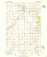
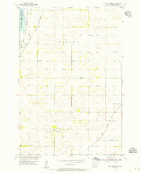
The Columbia townsite serves as the focal point of this 1952 landscape, situated where the meandering James River and Elm River converge in Brown County. This survey reflects a mid-century agricultural corridor defined by extensive water management and rail connectivity. A system of earthen Levee structures follows the tight oxbows of the James River, highlighting the historical efforts to control the floodplain for farming. Two major rail lines intersect the region: the Chicago and North Western passes through the northern sections near Columbia, while the Great Northern cuts across the southern portion near the small settlement of Plana. The distribution of rural education is captured in transition, showing the Davis Sch alongside the already noted School No 2 (Abandoned), documenting the consolidation of the rural school system in the Missouri River Basin.
Find a feature on this map
15 named features on this map. Tap any name to fly to it.
Don’t see what you’re looking for? This feature index may not catch every label — zoom into the map to look around manually.
Map Details
Editions of this 1952 Columbia Map
This is the sole edition of this map. No revisions or reprints were ever made.
Other maps of this area

1894 · Columbia
USGS Topo · 1:62,500

1895 · Aberdeen
USGS Topo · 1:125,000

1896 · Columbia
USGS Topo · 1:125,000

1952 · Ordway
USGS Topo · 1:24,000

1952 · Columbia NE
USGS Topo · 1:24,000
1952 · Westport
USGS Topo · 1:24,000

1952 · Putney
USGS Topo · 1:24,000
1954 · Bath
USGS Topo · 1:24,000
1954 · James
USGS Topo · 1:24,000
1954 · Daly Corners
USGS Topo · 1:24,000
Featured Places
- Columbia, Columbia Township
- Henry Township, SD
- Bath Township, SD
- Ordway Township, SD
- Cambria Township, SD