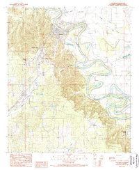
1989 Map of Columbia
USGS Topo · Published 1989About this map
The Ouachita River defines this landscape in Caldwell Parish, carving deep meanders through the alluvial bottomlands and shaping the development of the region. On the western bluffs, the town of Columbia serves as a focal point, supported by nearby residential clusters at Columbia Heights and Banks Springs. The terrain contrasts sharply between the elevated hills to the west, where Hurricane Creek flows, and the labyrinthine network of oxbow lakes and brakes to the east, including Humble Lake, Dizzy Brake, and Lower Long Lake. Evidence of the area's timber and transport history is visible in the industrial labeling of Pulpwood Spur and the presence of the Caldwell Parish Airport. Smaller rural communities like Grayson, Bellevue, and Copenhagen are mapped alongside numerous bayous and sloughs, such as Sillars Bayou and Indian Slough, illustrating the complex water-dependent geography of north-central Louisiana in the late 1980s.
Find a feature on this map
31 named features on this map. Tap any name to fly to it.
Don’t see what you’re looking for? This feature index may not catch every label — zoom into the map to look around manually.
Map Details
Editions of this 1989 Columbia Map
This is the sole edition of this map. No revisions or reprints were ever made.
Other maps of this area

1939 · Fort Necessity
USGS Topo · 1:62,500

1940 · Columbia
USGS Topo · 1:62,500

1941 · Harrisonburg
USGS Topo · 1:62,500

1953 · Alexandria
USGS Topo · 1:250,000

1953 · Natchez
USGS Topo · 1:250,000

1955 · Jackson
USGS Topo · 1:250,000

1955 · Shreveport
USGS Topo · 1:250,000

1955 · Alexandria
USGS Topo · 1:250,000

1955 · Olla
USGS Topo · 1:62,500

1956 · Shreveport
USGS Topo · 1:250,000