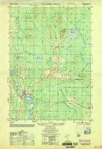
1953 Map of Columbia Falls
USGS Topo · Published 1953About this map
The Pleasant River and Chandler River define the hydraulic character of this Washington County landscape, which in the early 1950s remained largely defined by its wetland heaths and timbered ridges. The settlement of Columbia Falls serves as the primary hub, situated near where the Maine Central railroad tracks cross the river. Further north, the small community of Centerville sits at the base of Pecky Brook, while the isolated Jonesboro Station marks a critical point of transport for the eastern section of the map.
Find a feature on this map
39 named features on this map. Tap any name to fly to it.
Don’t see what you’re looking for? This feature index may not catch every label — zoom into the map to look around manually.
Map Details
Editions of this 1953 Columbia Falls Map
This is the sole edition of this map. No revisions or reprints were ever made.
Other maps of this area

1902 · Cherryfield
USGS Topo · 1:62,500

1904 · Cherryfield
USGS Topo · 1:62,500

1921 · Columbia Falls
USGS Topo · 1:62,500

1921 · Columbia Falls
USGS Topo · 1:62,500

1941 · Columbia Falls
USGS Topo · 1:62,500

1941 · Wesley
USGS Topo · 1:62,500

1941 · Tug Mountain
USGS Topo · 1:62,500

1942 · Cherryfield
USGS Topo · 1:62,500

1942 · Columbia Falls
USGS Topo · 1:62,500

1943 · Tug Mountain
USGS Topo · 1:62,500