
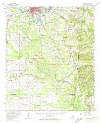
1960 Map of Columbus
USGS Topo · Published 1961About this map
The Tombigbee River anchors this study of Eastern Mississippi at the turn of the 1960s, winding through deep oxbows like Hairston Bend as it flows south from Columbus. The map reveals a landscape defined by its waterways and transit lines, including the Gulf Mobile and Ohio and St Louis-San Francisco railroads. Outside the growing city, the quadrangle is dotted with rural landmarks essential for genealogists, from the Barrow Sch to the St Mathis Cem and numerous country churches like Zion Hill Ch. Evidence of the local economy is visible in the clusters of Gravel Pits and the functional infrastructure of the Nashville Ferry, while the presence of the Columbus Lowndes Co Airport and Greenlawn Memorial Park signals the mid-century expansion of the county seat.
Find a feature on this map
76 named features on this map. Tap any name to fly to it.
Don’t see what you’re looking for? This feature index may not catch every label — zoom into the map to look around manually.
Map Details
Editions of this 1960 Columbus Map
2 editions found
Other maps of this area

1953 · West Point
USGS Topo · 1:250,000

1958 · West Point
USGS Topo · 1:250,000

1959 · Artesia
USGS Topo · 1:62,500

1959 · West Point
USGS Topo · 1:62,500

1960 · Caledonia
USGS Topo · 1:62,500

1963 · West Point
USGS Topo · 1:250,000

1966 · Ethelsville
USGS Topo · 1:24,000

1966 · Reform SW
USGS Topo · 1:24,000

1967 · Fernbank
USGS Topo · 1:24,000

1970 · Aliceville North
USGS Topo · 1:24,000