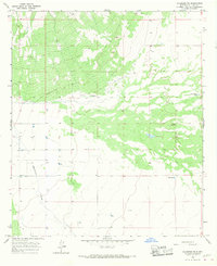
1966 Map of Columbus NE
USGS Topo · Published 1967About this map
Seventysix Draw winds through this arid corner of Luna County, where the survival of cattle and livestock depended entirely on the strategic placement of wells and water catchments. The landscape is defined by the practical infrastructure of ranching during the mid-1960s, featuring numerous labeled Well sites and isolated water sources like Oney Tank and Buena Vista Tank. A network of unimproved dirt roads and a singular Jeep Trail provide the only access through this desert terrain, connecting the open range to vital landmarks like the Coyote Windmill and Lucky Windmill. This map reveals a specific reliance on groundwater management in the high desert, where ephemeral features such as Dry Lake contrast with the permanent utility of the scattered windmills and tanks.
Find a feature on this map
12 named features on this map. Tap any name to fly to it.
Don’t see what you’re looking for? This feature index may not catch every label — zoom into the map to look around manually.
Map Details
Editions of this 1966 Columbus NE Map
This is the sole edition of this map. No revisions or reprints were ever made.
Other maps of this area

1899 · Deming
USGS Topo · 1:125,000

1915 · Deming
USGS Topo · 1:125,000

1917 · Camel Mountain
USGS Topo · 1:62,500

1917 · Columbus
USGS Topo · 1:62,500

1918 · Columbus
USGS Topo · 1:62,500

1920 · Columbus
USGS Topo · 1:62,500

1953 · El Paso
USGS Topo · 1:250,000

1955 · Las Cruces
USGS Topo · 1:250,000

1958 · Las Cruces
USGS Topo · 1:250,000

1959 · El Paso
USGS Topo · 1:250,000