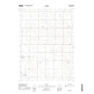
2017 Map of Concord
USGS Topo · Published 2017About this map
The villages of Dixon and Concord anchor this Dixon County landscape, illustrating the rural settlement pattern of northeast Nebraska. The terrain is defined by a grid of section roads and the winding paths of Jordan Cr and N Logan Cr. Water management is evident through features like the Logan Cr Dredge and the Old Channel Logan Creek, reflecting historical efforts to control drainage in this agricultural region. Small-scale reservoirs such as Blohm Reservoir and Fharenholtz Reservoir are interspersed among the rolling hills, providing local water sources. For those tracing family history, the map identifies local landmarks including Saint Annes Cem and the Concord Cem, situated near the residential streets of the towns. Local road names such as Old US Hwy 20 and various numbered routes like 872 Rd provide a clear reference for the 21st-century infrastructure of the area.
Find a feature on this map
47 named features on this map. Tap any name to fly to it.
Don’t see what you’re looking for? This feature index may not catch every label — zoom into the map to look around manually.
Map Details
Editions of this 2017 Concord Map
This is the sole edition of this map. No revisions or reprints were ever made.
Other maps of this area

1898 · Elk Point
USGS Topo · 1:125,000

1901 · Elk Point
USGS Topo · 1:125,000

1907 · Elk Point
USGS Topo · 1:125,000

1955 · Sioux City
USGS Topo · 1:250,000

1958 · Sioux City
USGS Topo · 1:250,000

1959 · Sioux City
USGS Topo · 1:250,000

1964 · Martinsburg SW
USGS Topo · 1:24,000
1964 · Martinsburg
USGS Topo · 1:24,000
1967 · Allen
USGS Topo · 1:24,000

1967 · Wakefield SW
USGS Topo · 1:24,000