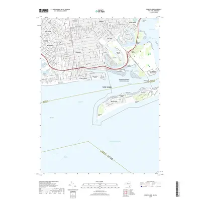
2019 Map of Coney Island
USGS Topo · Published 2019About this map
The dense urban grid of southern Brooklyn meets the Atlantic shoreline in this detailed modern record. Long-established neighborhoods like Bensonhurst and Gravesend are characterized by their cultural and religious infrastructure, featuring prominent institutions such as the Mirrer Yeshiva Central Institute and the Beth Hatalmud Rabbinical College. To the north, the expansive Washington Cem remains a significant local landmark amidst the residential blocks. The coastline is defined by its recreational and educational spaces, from the sands of Brighton Beach and Manhattan Beach to the campus of Kingsborough Community College on the eastern edge of Coney Island. Across the Rockaway Inlet, the barrier beach at Breezy Point and Roxbury provides a stark contrast to the mainland, with much of the area preserved within the Gateway National Recreation Area, protecting the complex geography of Jamaica Bay and Dead Horse Bay.
Find a feature on this map
69 named features on this map. Tap any name to fly to it.
Don’t see what you’re looking for? This feature index may not catch every label — zoom into the map to look around manually.
Map Details
Editions of this 2019 Coney Island Map
This is the sole edition of this map. No revisions or reprints were ever made.
Other maps of this area

1888 · Sandy Hook
USGS Topo · 1:62,500

1889 · Brooklyn
USGS Topo · 1:62,500

1891 · Brooklyn
USGS Topo · 1:62,500

1893 · Sandy Hook
USGS Topo · 1:62,500

1897 · Brooklyn
USGS Topo · 1:62,500

1898 · Staten Island
USGS Topo · 1:62,500

1898 · Brooklyn
USGS Topo · 1:62,500

1900 · Passaic
USGS Topo · 1:125,000

1900 · Staten Island
USGS Topo · 1:62,500

1900 · Brooklyn
USGS Topo · 1:62,500