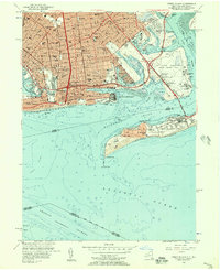
1955 Map of Coney Island
USGS Topo · Published 1957About this map
Coney Island and the southern reaches of Brooklyn are captured here during a period of significant military and residential density in the mid-1950s. The map illustrates a landscape where massive infrastructure like the Shore Parkway and Marine Parkway Bridge connects established neighborhoods such as Bensonhurst, Gravesend, and Flatlands. While the coast is famous for leisure at Brighton Beach and the Rigelmann Boardwalk, the eastern portions are dominated by federal activity. The US Naval Reservation Floyd Bennett Field and the US Air Force Reservation Manhattan Beach Station highlight the area's strategic importance during the Cold War.
Find a feature on this map
112 named features on this map. Tap any name to fly to it.
Don’t see what you’re looking for? This feature index may not catch every label — zoom into the map to look around manually.
Map Details
Editions of this 1955 Coney Island Map
This is the sole edition of this map. No revisions or reprints were ever made.
Other maps of this area

1888 · Sandy Hook
USGS Topo · 1:62,500

1889 · Brooklyn
USGS Topo · 1:62,500

1891 · Brooklyn
USGS Topo · 1:62,500

1893 · Sandy Hook
USGS Topo · 1:62,500

1897 · Brooklyn
USGS Topo · 1:62,500

1898 · Staten Island
USGS Topo · 1:62,500

1898 · Brooklyn
USGS Topo · 1:62,500

1900 · Passaic
USGS Topo · 1:125,000

1900 · Staten Island
USGS Topo · 1:62,500

1900 · Brooklyn
USGS Topo · 1:62,500