
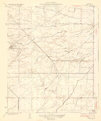
1930 Map of Conner
USGS Topo · Published 1930About this map
Agricultural development and water management define this Central Valley landscape during the early 1930s. The region is marked by a complex network of irrigation infrastructure including the Kern Island Canal, Old Rim Ditch, and New Rim Ditch, which supported large-scale operations such as Lakeside Ranch and Kern Lake Ranch. A distinctive social element of this era is visible in the presence of specialized educational facilities like the Shafter Migratory Sch and Ordena Migratory Sch, reflecting the seasonal labor patterns of the time. Local commerce and industry are further anchored by the Oil Pumping Sta and a small settlement at Conner. Transportation across the basin relied on a grid of early thoroughfares such as Maricopa Road and Pacific Highway, which connected remote ranch holdings to the broader regional economy.
Find a feature on this map
30 named features on this map. Tap any name to fly to it.
Don’t see what you’re looking for? This feature index may not catch every label — zoom into the map to look around manually.
Map Details
Editions of this 1930 Conner Map
This is the sole edition of this map. No revisions or reprints were ever made.
Other maps of this area

1910 · Buena Vista Lake
USGS Topo · 1:125,000

1912 · Buena Vista Lake
USGS Topo · 1:125,000

1914 · Caliente
USGS Topo · 1:125,000

1929 · Stevens
USGS Topo · 1:31,680

1929 · Fairfax School
USGS Topo · 1:31,680

1930 · Weed Patch
USGS Topo · 1:31,680

1930 · Millux
USGS Topo · 1:31,680

1931 · West of Tejon Hills
USGS Topo · 1:31,680

1931 · Hayes Ranch
USGS Topo · 1:31,680
1932 · Stevens
USGS Topo · 1:31,680