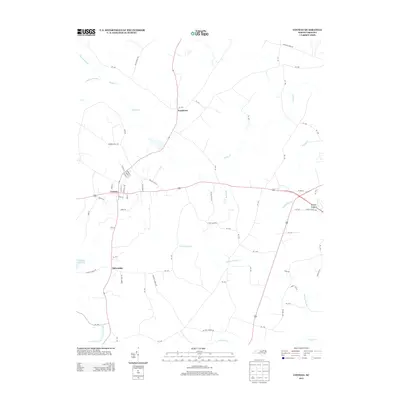
2013 Map of Conway
USGS Topo · Published 2013About this map
Conway and the surrounding agricultural lands of Northampton County are defined by a network of slow-moving watercourses and wetland systems. The landscape is structured around significant drainage features such as Panther Swamp, Rogers Swamp, and Corduroy Swamp, which influence the local road patterns and land use. Small residential clusters and agricultural hubs like Pendleton and Milwaukee are linked by a dense grid of secondary routes, including William Beal RD and Deberrys Mill RD.
Find a feature on this map
75 named features on this map. Tap any name to fly to it.
Don’t see what you’re looking for? This feature index may not catch every label — zoom into the map to look around manually.
Map Details
Editions of this 2013 Conway Map
This is the sole edition of this map. No revisions or reprints were ever made.
Other maps of this area

1919 · Boykins
USGS Topo · 1:48,000

1919 · Arringdale
USGS Topo · 1:48,000

1920 · Boykins
USGS Topo · 1:62,500

1920 · Arringdale
USGS Topo · 1:62,500

1942 · Arringdale
USGS Topo · 1:62,500

1953 · Norfolk
USGS Topo · 1:250,000

1966 · Margarettsville
USGS Topo · 1:24,000

1966 · Sunbeam
USGS Topo · 1:24,000
1966 · Boykins
USGS Topo · 1:24,000
1973 · Murfreesboro
USGS Topo · 1:24,000