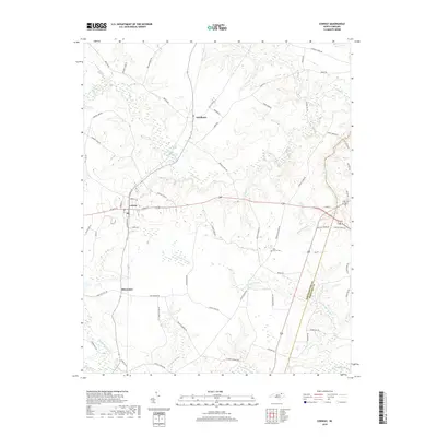
2019 Map of Conway
USGS Topo · Published 2019About this map
The town of Conway serves as a central hub on this North Carolina Coastal Plain landscape, where the local road network radiates toward surrounding agricultural and woodland areas. This 2019 survey documents the enduring spatial relationship between established settlements and the complex drainage systems of Northampton County. Significant water bodies like Panther Swamp and Corduroy Swamp dominate the low-lying terrain, while Potecasi Cr and Kirbys Creek define the hydrologic boundaries of the region.
Find a feature on this map
67 named features on this map. Tap any name to fly to it.
Don’t see what you’re looking for? This feature index may not catch every label — zoom into the map to look around manually.
Map Details
Editions of this 2019 Conway Map
This is the sole edition of this map. No revisions or reprints were ever made.
Other maps of this area

1919 · Boykins
USGS Topo · 1:48,000

1919 · Arringdale
USGS Topo · 1:48,000

1920 · Boykins
USGS Topo · 1:62,500

1920 · Arringdale
USGS Topo · 1:62,500

1942 · Arringdale
USGS Topo · 1:62,500

1953 · Norfolk
USGS Topo · 1:250,000

1966 · Margarettsville
USGS Topo · 1:24,000

1966 · Sunbeam
USGS Topo · 1:24,000
1966 · Boykins
USGS Topo · 1:24,000
1973 · Murfreesboro
USGS Topo · 1:24,000