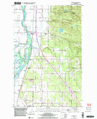
1998 Map of Conway
USGS Topo · Published 2003About this map
The deltaic lowlands and rising foothills of the Skagit River South Fork define this late-twentieth-century landscape. Centered on Conway, the map illustrates a complex network of waterways including Steamboat Slough, Tom Moore Slough, and Freshwater Slough, which weave through the agricultural flats south of Fir Station. The transition from the alluvial plain to the uplands is marked by prominent elevations such as Scott Mtn and Devils Mtn, overlooking Ten Lake and Sixteen Lake. Infrastructure and small-scale settlements like Milltown and Cedardale follow the primary transit corridors, while localized features such as the Conway Sch and Freeborn Church indicate the social hubs of these rural communities. To the south, the boundary between Skagit Co Snohomish Co passes through a region of scattered gravel pits and small reservoirs, reaching down toward East Stanwood and Cedarhome.
Find a feature on this map
49 named features on this map. Tap any name to fly to it.
Don’t see what you’re looking for? This feature index may not catch every label — zoom into the map to look around manually.
Map Details
Editions of this 1998 Conway Map
This is the sole edition of this map. No revisions or reprints were ever made.
Other maps of this area

1911 · Mount Vernon
USGS Topo · 1:125,000

1940 · Mt Vernon
USGS Topo · 1:62,500

1941 · Marysville
USGS Topo · 1:62,500

1943 · Marysville
USGS Topo · 1:62,500

1943 · Mt Vernon
USGS Topo · 1:62,500

1943 · Stanwood
USGS Topo · 1:62,500

1944 · Clear Lake
USGS Topo · 1:62,500
1956 · Arlington West
USGS Topo · 1:24,000
1956 · Stanwood
USGS Topo · 1:24,000
1956 · Utsalady
USGS Topo · 1:24,000