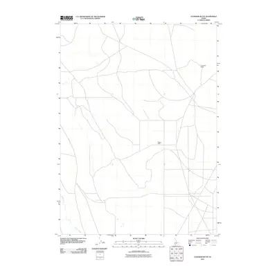
2010 Map of Coonskin Butte
USGS Topo · Published 2010About this map
Coonskin Butte rises as a prominent landmark in this high desert landscape of Owyhee County, surveyed during the first decade of the 21st century. The terrain is defined by its wide, open spaces and a sparse network of unpaved tracks, including the Maiat Trl, which navigates the northwestern corner of the quadrangle. In the south, Clover Creek cuts through the flats, providing one of the few named watercourses in this arid region. The map also identifies Aikers Field, a remote landing strip that suggests the importance of light aircraft for accessing such isolated backcountry. This 2010 topographic record captures the essential character of the Idaho rangelands, where human imprints are few and far between, centered mostly around aviation and primitive transit routes.
Find a feature on this map
4 named features on this map. Tap any name to fly to it.
Don’t see what you’re looking for? This feature index may not catch every label — zoom into the map to look around manually.
Map Details
Editions of this 2010 Coonskin Butte Map
This is the sole edition of this map. No revisions or reprints were ever made.
Other maps of this area

1955 · Twin Falls
USGS Topo · 1:250,000

1958 · Twin Falls
USGS Topo · 1:250,000

1979 · Salls Crossing
USGS Topo · 1:24,000

1979 · Mosquito Lake Butte
USGS Topo · 1:24,000

1979 · Coonskin Butte NE
USGS Topo · 1:24,000

1979 · Coonskin Butte
USGS Topo · 1:24,000

1980 · Juniper Butte
USGS Topo · 1:24,000
1980 · Juniper Ranch
USGS Topo · 1:24,000
1980 · Horse Butte
USGS Topo · 1:24,000
1980 · Grassy Hills
USGS Topo · 1:24,000