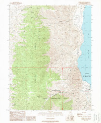
1988 Map of Copper Canyon
USGS Topo · Published 1989About this map
The Hawthorne Army Ammunition Plant dominates the desert floor in this 1980s survey, illustrating the significant military presence on the western shore of Walker Lake. The map details the transition from the high ridges of the Wassuk Range down to the water's edge, where a Trailer Park and multiple Boat Ramps mark the recreational use of the shoreline. The industrial and military footprint is balanced by a rugged network of drainage systems and watering points essential for this arid climate, including Wild Horse Spring, Schuet Springs, and Chipmunk Spring. Prospectors have left their mark across the canyons, with numerous Prospects and an Adit noted near the ammunition plant boundary. Canyons like Copper Canyon and Dry Creek carve through the mountains, while man-made features like a Check Dam reflect efforts to manage the sparse but sudden water flow in this high-desert environment.
Find a feature on this map
24 named features on this map. Tap any name to fly to it.
Don’t see what you’re looking for? This feature index may not catch every label — zoom into the map to look around manually.
Map Details
Editions of this 1988 Copper Canyon Map
This is the sole edition of this map. No revisions or reprints were ever made.
Other maps of this area

1909 · Hawthorne
USGS Topo · 1:250,000

1911 · Hawthorne
USGS Topo · 1:250,000

1915 · Hawthorne
USGS Topo · 1:250,000

1948 · Walker Lake
USGS Topo · 1:250,000

1955 · Hawthorne
USGS Topo · 1:62,500

1956 · Mt. Grant
USGS Topo · 1:62,500

1957 · Walker Lake
USGS Topo · 1:250,000

1962 · Walker Lake
USGS Topo · 1:250,000

1964 · Walker Lake
USGS Topo · 1:250,000

1964 · Gillis Canyon
USGS Topo · 1:62,500