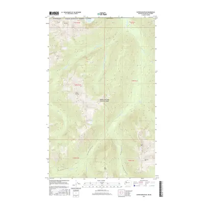
2017 Map of Copper Mountain
USGS Topo · Published 2017About this map
North Cascades National Park dominates this high-elevation landscape along the international border, where the rugged terrain of Whatcom County meets British Columbia. The map documents a complex drainage system centered on the Little Chilliwack River and its various tributaries, including the Little Fork Little Chilliwack River and Brush Cr. Notable peaks such as Copper Mountain, Mid Peak, and Indian Mtn define the vertical scale of the region. High-altitude water bodies like Hanging Lake, Egg Lake, and Copper Lake are interspersed among the ridges. For those traversing the wilderness, the Pacific NW National Scenic Trail provides the primary overland corridor, winding past Easy Ridge and through the deep valleys that characterize this preserved natural area at the edge of the United States.
Find a feature on this map
34 named features on this map. Tap any name to fly to it.
Don’t see what you’re looking for? This feature index may not catch every label — zoom into the map to look around manually.
Map Details
Editions of this 2017 Copper Mountain Map
This is the sole edition of this map. No revisions or reprints were ever made.
Other maps of this area

1909 · Mt Baker
USGS Topo · 1:192,000

1915 · Mt. Baker
USGS Topo · 1:250,000

1953 · Mt Shuksan
USGS Topo · 1:62,500

1953 · Mt Challenger
USGS Topo · 1:62,500

1955 · Concrete
USGS Topo · 1:250,000

1958 · Concrete
USGS Topo · 1:250,000

1962 · Concrete
USGS Topo · 1:250,000

1979 · Mt. Baker
USGS Topo · 1:100,000
1989 · Copper Mountain
USGS Topo · 1:24,000
1989 · Mount Blum
USGS Topo · 1:24,000