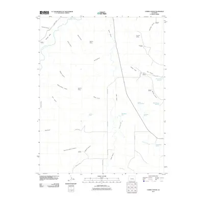
2010 Map of Corbin Canyon
USGS Topo · Published 2010About this map
Martinez Cemetery sits near the winding Purgatoire River in the northwest corner of this Otero County landscape, marking an early focal point for local families. The terrain is defined by a dense network of drainages and seasonal watercourses, including Gaussion Canyon and Porterfield Canyon. This environment necessitated an extensive water management system visible through features like the Ninemile Canal and Two Buttes Canal. Numerous reservoirs and ponds, such as East Canyon Reservoir and Harbordale Pond, suggest a landscape shaped by ranching and irrigation needs.
Find a feature on this map
47 named features on this map. Tap any name to fly to it.
Don’t see what you’re looking for? This feature index may not catch every label — zoom into the map to look around manually.
Map Details
Editions of this 2010 Corbin Canyon Map
This is the sole edition of this map. No revisions or reprints were ever made.
Other maps of this area

1891 · Higbee
USGS Topo · 1:125,000

1891 · Timpas
USGS Topo · 1:125,000

1893 · Higbee
USGS Topo · 1:125,000

1894 · Timpas
USGS Topo · 1:125,000

1955 · La Junta
USGS Topo · 1:250,000

1958 · La Junta
USGS Topo · 1:250,000

1966 · La Junta SE
USGS Topo · 1:24,000
1966 · Turkey Canyon
USGS Topo · 1:24,000
1966 · Higbee
USGS Topo · 1:24,000

1968 · La Junta
USGS Topo · 1:250,000