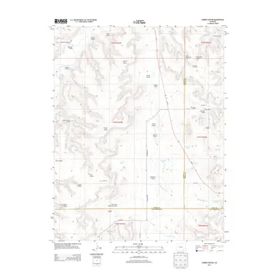
2013 Map of Corbin Canyon
USGS Topo · Published 2013About this map
The Purgatoire River winds through this arid southeastern Colorado landscape, carving out a complex network of canyons and draws at the junction of Otero, Bent, and Las Animas Counties. This 2013 survey illustrates a region defined by livestock and water management, where named windmills like the Anstine Windmill, Porterfield Windmill, and Barnhart Windmill serve as essential landmarks across the high mesa. The terrain is deeply incised by features such as Gaussien Canyon, School Section Canyon, and Corbin Canyon, while the local hydrology is managed through works like the Ninemile Canal and Two Buttes Canal. Numerous small water catchments, including Lemley Pond and the E Canyon Reservoir, dot the land along Co-109 and Villegreen RD, reflecting the persistent efforts to harness runoff in the dry drainage basins of Eightmile Canyon and Harbordale Arroyo.
Find a feature on this map
56 named features on this map. Tap any name to fly to it.
Don’t see what you’re looking for? This feature index may not catch every label — zoom into the map to look around manually.
Map Details
Editions of this 2013 Corbin Canyon Map
This is the sole edition of this map. No revisions or reprints were ever made.
Other maps of this area

1891 · Higbee
USGS Topo · 1:125,000

1891 · Timpas
USGS Topo · 1:125,000

1893 · Higbee
USGS Topo · 1:125,000

1894 · Timpas
USGS Topo · 1:125,000

1955 · La Junta
USGS Topo · 1:250,000

1958 · La Junta
USGS Topo · 1:250,000

1966 · La Junta SE
USGS Topo · 1:24,000
1966 · Turkey Canyon
USGS Topo · 1:24,000
1966 · Higbee
USGS Topo · 1:24,000

1968 · La Junta
USGS Topo · 1:250,000