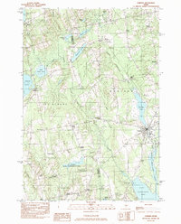
1982 Map of Corinna
USGS Topo · Published 1983About this map
The Sebasticook River valley defines this region of Maine during the early 1980s, centering on the hub of Corinna. The town sits at the intersection of water and industry, characterized by the Corundel Lake dam and the East Branch Sebasticook River. The landscape is notably dotted with numerous "Corners"—small, traditional crossroads settlements like Lyford Corner, Five Corners, and Nutter Corner—that reflect the ancestral township divisions of Ripley, Dexter, and St Albans. In the southwest, the St Albans Game Management Area protects a mosaic of wetlands including Little Indian Pond. The geography is heavily influenced by glacial water bodies, with Mower Pond, Weymouth Pond, and the northern reaches of Sebasticook Lake providing a permanent framework for the local rural economy and recreational layout.
Find a feature on this map
47 named features on this map. Tap any name to fly to it.
Don’t see what you’re looking for? This feature index may not catch every label — zoom into the map to look around manually.
Map Details
Editions of this 1982 Corinna Map
This is the sole edition of this map. No revisions or reprints were ever made.
Other maps of this area

1930 · Pittsfield
USGS Topo · 1:48,000

1931 · Stetson
USGS Topo · 1:48,000

1932 · Dover-Foxcroft
USGS Topo · 1:48,000

1932 · Pittsfield
USGS Topo · 1:62,500

1933 · Pittsfield
USGS Topo · 1:62,500

1933 · Guilford
USGS Topo · 1:62,500

1935 · Dover-Foxcroft
USGS Topo · 1:62,500

1935 · Stetson
USGS Topo · 1:62,500

1937 · Guilford
USGS Topo · 1:62,500

1948 · Bangor
USGS Topo · 1:250,000